Maps/Infographics
I am having fun playing with geospatial and remote sensing data. Have a look selected maps/infographics that I have ever made!
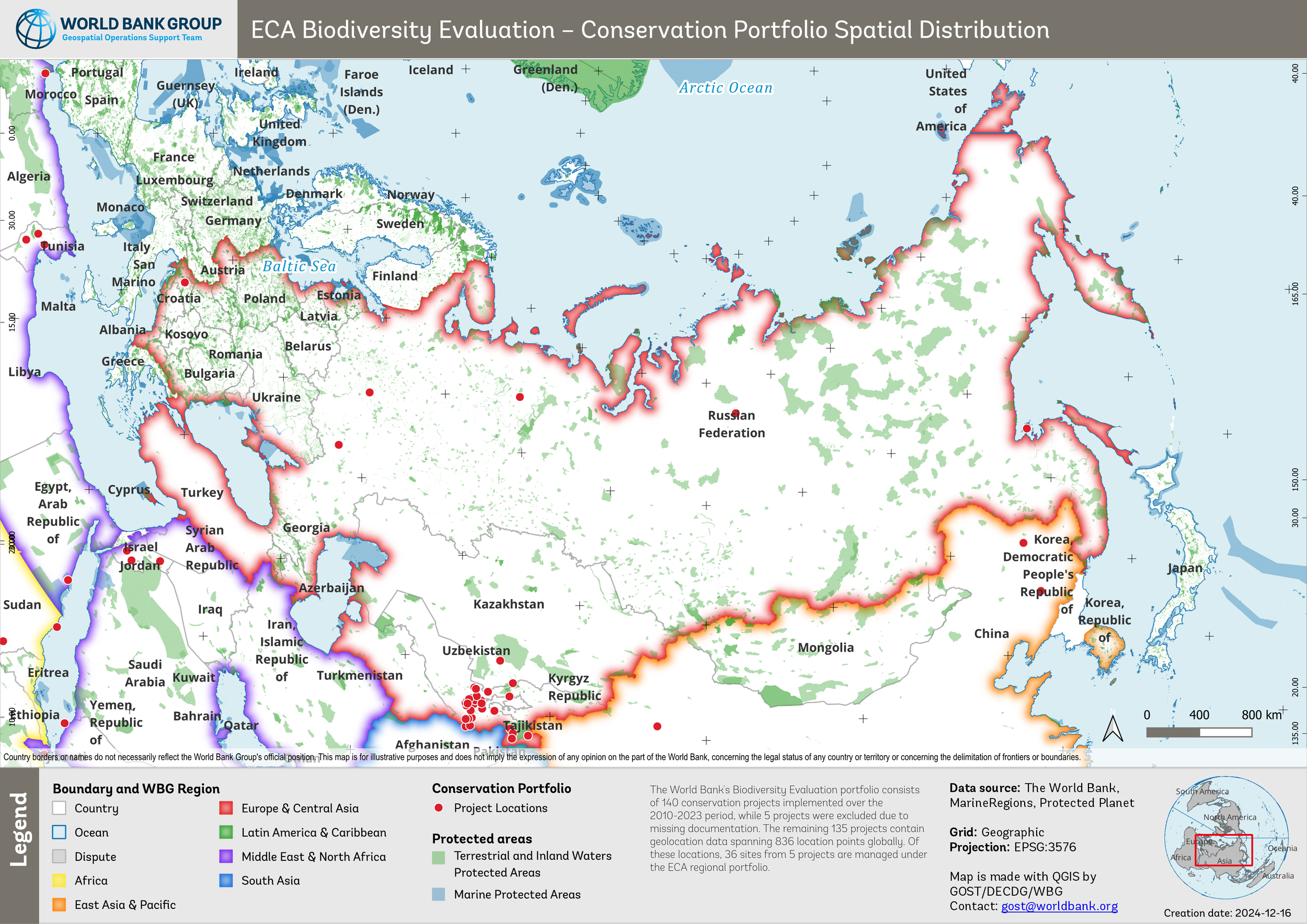
2024. The World Bank. Biodiversity Evaluation. QGIS 3.22.9
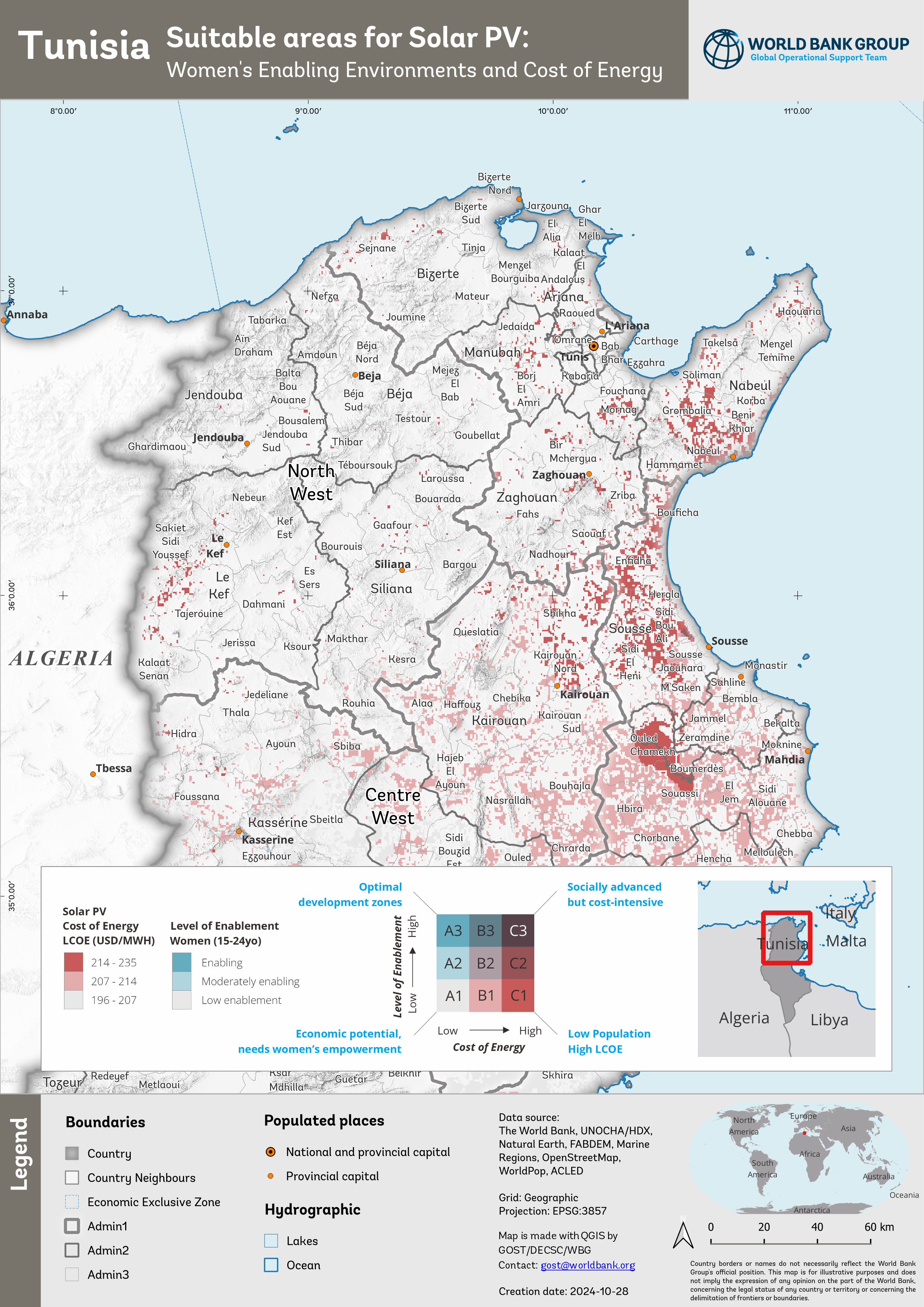
2024. The World Bank. GEEST Level of Enablement Women. QGIS 3.22.9

2023. The World Bank. Myanmar crop harvest status. QGIS 3.22.9

2023. The World Bank. Myanmar EVI ratio anomaly. QGIS 3.22.9

2023. The World Bank. Syrian Arab Republic - Standardize Precipitation-Evapotranspiration Index. QGIS 3.22.9

2023. The World Bank. Syrian Arab Republic - Temperature anomaly. QGIS 3.22.9

2023. The World Bank. Syrian Arab Republic - Vegetation Condition Index. QGIS 3.22.9

2022. The World Bank. Ukraine population 2021. QGIS 3.22.9

2022. The World Bank. Ukraine power plant. QGIS 3.22.9

2022. The World Bank. Ukraine general administration. QGIS 3.22.9

2022. The World Bank. Ukraine land cover and mine incidents. QGIS 3.16.8

2021. WFP. Tropical Cyclone Seroja. ArcGIS 10.8

2020. WFP. Facebook population movement. ArcGIS 10.7

2020. WFP. COVID-19 data preparedness. ArcGIS 10.7
https://mapgallery.esri.com/submission-detail/609d7f2195ac006b209082e3

2020. WFP. Travel time to nearest market. ArcGIS 10.7

2019. WFP. Rainfall forecast. ArcGIS 10.7

2020. WFP. Vegetation anomaly. ArcGIS 10.7

2019. WFP. Snow water equivalent. ArcGIS 10.7

2019. WFP. Wet-spell. ArcGIS 10.7

2018. WFP. Disaster snapshot. ArcGIS 10.4, Google Slide.
The Agence France-Presse (AFP) Graphics team requested permission via email to adapt this map for international distribution.
References: (1) https://au.news.yahoo.com/sick-hungry-indonesia-tsunami-survivors-cram-shelters-032750961--spt.html (2) https://victorfairen.wordpress.com/wp-content/uploads/2019/02/map-showing-tsunami-affected-areas-around-sunda-strait.jpg (3) https://www.dailymail.co.uk/news/article-6529497/Indonesia-rescuers-scramble-reach-isolated-tsunami-struck-towns.html (4) https://www.lunion.fr/id25995/article/2018-12-27/lindonesie-releve-le-niveau-dalerte-du-volcan-responsable-du-tsunami

2018. WFP. Central Sulawesi Earthquake Response. ArcGIS 10.4

2018. WFP. General logistics and planning. ArcGIS 10.4

2018. WFP. Travel time. ArcGIS 10.4

2018. WFP. VAMPIRE drought alert. ArcGIS 10.4, Google Slide

2018. WFP. Dry-spell. ArcGIS 10.4

2017. WFP. VAMPIRE flood alert. ArcGIS 10.4, Google Slide

2017. WFP. Dry-spell. ArcGIS 10.4


2016. WFP. Highlight activities. ArcGIS 10.4. CorelDRAW 12

2016. WFP. Pidie earthquake. ArcGIS 10.3

2016. WFP. Rainfall anomaly. ArcGIS 10.3

2016. WFP. Vegetation health index. ArcGIS 10.3

2015. WFP. Facebook population. ArcGIS 10.2.2

2014. WFP. Province infographic. ArcGIS 10.2.2, Illustrator

2013. WFP. Food for Assets. ArcGIS 10.2.2

2013. WFP and BNPB. Jakarta flood. ArcGIS 10.2.2

2012. ILO. Road condition. ArcGIS 10

2012. ILO. LRB factsheet. CorelDRAW 12
2010. UNOCHA. Mentawai Tsunami Response. ArcGIS 9.3

2010. UNOCHA. Mentawai Tsunami Response. ArcGIS 9.3

2009. UNOCHA. West Sumatra Earthquake Response. ArcGIS 9.3

2007. MCC International. Immunization project. ArcView GIS 3.3

2007. Ministry of Forestry. Ciliwung Cisadane Flood Project. ArcView GIS 3.3

2006. SSFFMP. Land cover analysis. ILWIS 3.4

2006. SSFFMP. Hotspot monitoring. ArcExplorer Java Edition

2006. LAPAN. Fire Danger Rating System. ArcView GIS 3.3

2004. IPB. Satellite meteorology assignment. ArcView 3.3, ERMapper 6.4